|
Back to
NRT
|
-

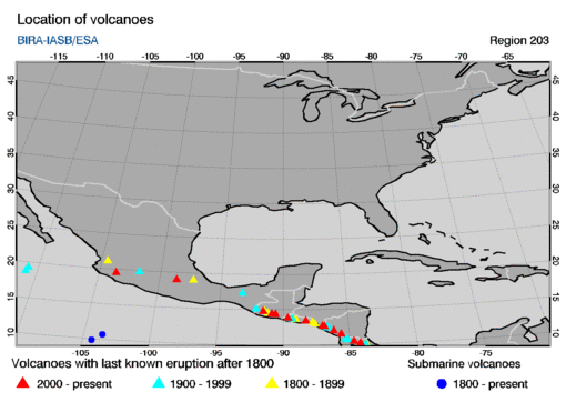
- region type: rectangular region
- region size: 40 by 40 degrees
- region centre: (longitude,latitude) = (-90,30)
-
- Most recent SO2 concentration date for this region:
-
This region encompasses the following volcanoes with last known eruptions
since 1800 AD. The name of a volcano in the table below is a link to
an info-page at the website of the
Global Volcanism Programme (GVP).
The table gives the summit elevation (in meters) and the year of the last
known eruption, omitting any uncertainties in these given at the GVP
website.
        location
      long.    lat.  summit  year   volcano name
   =================================================

     -84.23   10.20   2708   2019   Poás
     -84.70   10.46   1670   2010   Arenal
     -90.60   14.38   2552   2020   Pacaya
     -90.88   14.47   3763   2020   Fuego
     -91.55   14.76   3772   2012   Santa Maria
     -98.62   19.02   5426   2020   Popocatépetl
    -103.62   19.51   3850   2019   Colima
     -86.16   11.98    635   2020   Masaya
     -87.00   12.70   1745   2011   San Cristóbal
     -85.62   11.54   1700   2011   Concepción
     -86.85   12.60   1061   2018   Telica
     -89.63   13.85   2381   2005   Santa Ana
     -88.27   13.43   2130   2002   San María

     -86.70   12.51    728   1999   Cerro Negro
     -85.32   10.83   1916   2020   Rincón de la Vieja
     -92.11   15.13   4060   1986   Tacaná
     -93.23   17.36   1150   1982   El Chichón
     -90.88   14.50   3976   1972   Acatenango
     -89.63   13.81   1950   1966   Izalco
     -86.69   12.49   1088   1954   Las Pilas
    -101.75   19.85   3860   1952   Michoacán-Guanajuato
     -85.15   10.75   2028   1946   Miravalles
     -89.29   13.73   1893   1917   San Salvador
     -86.54   12.42   1297   1905   Momotombo

     -87.77   13.23    505   1892   Conchagüeita
     -89.05   13.67    450   1880   Ilopango
    -104.51   21.12   2280   1875   Ceboruco
     -83.77   10.02   3340   2012   Turrialba
     -87.57   12.98    872   1859   Cosigüeina
     -91.19   14.58   3535   1853   Atitlán
     -97.27   19.03   5675   1846   Pico de Orizaba
     -91.48   14.82   3197   1818   Almolonga

   submarine volcanoes

    -103.58   10.73   -100   2003   Unnamed
|