|
Back to
NRT
|
-

- region type: rectangular region
- region size: 40 by 40 degrees
- region centre: (longitude,latitude) = (-60,-30)
-
- Most recent SO2 concentration date for this region:
-
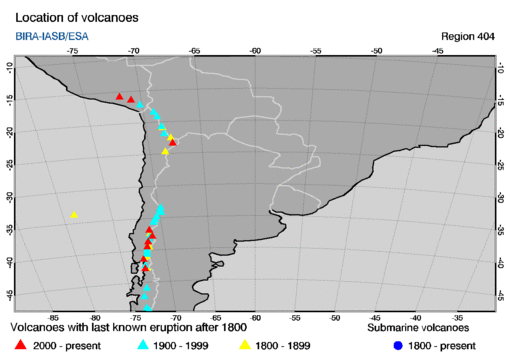
This region encompasses the following volcanoes with last known eruptions
since 1800 AD. The name of a volcano in the table below is a link to
an info-page at the website of the
Global Volcanism Programme (GVP).
The table gives the summit elevation (in meters) and the year of the last
known eruption, omitting any uncertainties in these given at the GVP
website.
        location
      long.    lat.  summit  year   volcano name
   =================================================

     -72.65  -42.83   1122   2011   Chaitén
     -71.73  -38.69   3125   2009   Llaima
     -70.90  -16.35   5672   2019   Ubinas
     -71.93  -39.42   2847   2020   Villarrica
     -67.73  -23.37   5592   2007   Lascar
     -71.38  -36.86   3212   2020   Nevados de Chillán
     -71.85  -15.78   5967   2020   Sabancaya
     -71.17  -37.85   2997   2020   Copahué

     -70.57  -35.24   4107   2019   Planchón-Peteroa
     -68.55  -20.73   5163   1995   Irruputuncu
     -72.97  -45.90   1905   1991   Cerro Hudson
     -72.12  -40.59   2236   2012   Puyehue-Cordon Caulle
     -71.58  -38.38   2865   1990   Lonquimay
     -73.28  -49.36   1500   1988   Viedma
     -69.80  -33.40   6000   1987   Tupungatito
     -71.45  -37.92   3164   1980   Callaqui
     -73.55  -49.02   3607   1979   Lautaro
     -73.48  -47.20   3437   1979   Arenales
     -72.07  -40.35   1114   1979   Carrán-Los Venados
     -72.61  -41.33   2003   2015   Calbuco
     -70.76  -35.65   3788   1967   Cerro Azul
     -69.90  -33.78   5856   1960   San José
     -68.40  -21.88   6145   1960   San Pedro
     -69.09  -18.42   6071   1960   Guallatiri
     -72.03  -39.93   2422   1937   Mocho-Choshuenco
     -70.75  -35.58   3953   1933   Descabezado Grande
     -72.58  -42.38   1318   1920   Huequi
     -70.35  -34.81   4280   1917   Tinguiririca
     -68.83  -19.15   5550   1913   Isluga
     -69.83  -34.16   5264   1912   Maipo
     -70.20  -17.18   5550   1902   Yucamane

     -68.53  -24.72   6739   1877   Llullaillaco
     -71.70  -39.50   2360   1872   Quetrupillan
     -72.49  -41.10   2652   1869   Osorno
     -71.35  -37.41   2979   1869   Antuco
     -68.48  -20.93   5407   1867   Olca-Paruma
     -72.26  -40.97   2493   1850   Puntiagudo-Cordón Cenizos
     -72.44  -42.79   2404   1835   Minchinmávida
     -78.85  -33.66    922   1835   Robinson Crusoe
     -67.85  -22.55   5890   1810   Putana
|