|
Back to
NRT
|
-

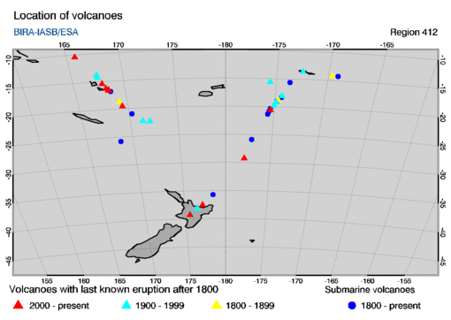
- region type: rectangular region
- region size: 40 by 40 degrees
- region centre: (longitude,latitude) = (180,-30)
-
- Most recent SO2 concentration date for this region:
-
This region encompasses the following volcanoes with last known eruptions
since 1800 AD. The name of a volcano in the table below is a link to
an info-page at the website of the
Global Volcanism Programme (GVP).
The table gives the summit elevation (in meters) and the year of the last
known eruption, omitting any uncertainties in these given at the GVP
website.
        location
      long.    lat.  summit  year   volcano name
   =================================================

     169.44  -19.53    361   2020   Yasur
     168.12  -16.25   1334   2018   Ambrym
    -175.38  -20.57    149   2009   Hunga Tonga-Hunga Ha'apai
     168.35  -16.51   1413   2007   Lopevi
     165.80  -10.38    851   2012   Tinakula
     175.57  -39.28   2797   2007   Ruapehu
     167.83  -15.40   1496   2011   Aoba
    -177.92  -29.27    516   2006   Raoul Island
     168.37  -16.68    833   2004   Epi
     177.18  -37.52    321   2019   White Island

    -174.87  -19.18     43   1995   Metis Shoal
    -175.63  -15.60    260   1985   Niuafo'ou
     167.50  -14.27    797   2010   Gaua
     176.50  -38.12   1111   1981   Okataina
     175.64  -39.13   1978   1977   Tongariro
     167.47  -13.80    921   1966   Suretamatai
    -175.07  -19.75    515   2011   Tofua
    -174.32  -18.02    180   1957   Fonualei
     171.32  -22.33    177   1956   Matthew Island
    -172.52  -13.61   1858   1911   Savai'i
     172.05  -22.40    297   1903   Hunter Island

     169.23  -18.75    837   1881   Traitor's Head
    -169.62  -14.18    639   1866   Ofu-Olosega
    -174.65  -18.81    540   1854   Late

   submarine volcanoes

    -177.19  -25.89   -100   2008   Monowai Seamount
    -174.77  -18.99     -2   2006   Home Reef
    -169.06  -14.22   -592   2003   Vailulu'u
    -174.37  -18.33    -40   2001   Unnamed
    -175.53  -20.85    -13   1999   Unnamed
     170.28  -20.98    -80   1996   Eastern Gemini Seamount
     178.48  -35.74   -220   2008   Rumble III
    -173.67  -15.62    -33   1979   Curacoa
     168.54  -16.83     -2   1974   Kuwae
     168.63  -25.78  -2400   1964   Unnamed
    -175.42  -20.32    -17   1936   Falcon Island
    -175.65  -21.38   -500   1932   Unnamed
|