| |
Background correction of the SO2 slant column data
A background correction is applied to the
SO2 slant columns retrieved with DOAS
based on satellite measurements. This section describes the
correction as it is applied to SCIAMACHY data; for GOME-2 the method is similar.
for OMI data the background correction is done differently (see for
info and links the section on
SO2 column from OMI).
There are two reasons to apply such a correction on the SCIAMACHY and GOME-2 data:
-
The DOAS retrieval requires the use of a
reference spectrum.
As reference spectrum for SCIAMACHY data a measurement is used from a
location thought to be free of SO2, but the retrieval can still lead to an
offset (bias) in the SO2 slant column.
-
At higher Solar Zenith Angels the "interference" between the SO2 and ozone
absorption -- mentioned in the SO2 slant columns
retrieval section -- results in more negative SO2 slant column values,
with large errors.
The following graph shows an example of the monthly average SO2 slant column
as function of SZA.

|
|
Average of the SO2 slant column as function of the SZA for March 2007 over
all data (green), of only the Northern hemisphere (blue) and of only the
Southern hemisphere (red). The decrease of the average SO2 slant column at
higher SZA is due to the increase in ozone absorption along the slant path
with increasing SZA.
|
From this graph it is not only clear that the retrieved SO2 slant column
decreases strongly at high SZA, but also that there is a difference between
the Northern and Southern hemisphere here. The reason for the latter
difference is that ozone concentrations near the South Pole are much lower
than near the North pole due to the presence of the "ozone hole" above
Antarctica in this month. This indicates that the correction for effects
of the "interference" at high SZA should be a function relating the SO2
slant column with the ozone concentration.
The monthly average SO2 slant column represents the background level of SO2
in the retrieval: on average, there will be not much SO2 in the atmosphere,
as SO2 emissions are highly localised and SO2 has a short lifetime in the
atmosphere (in the troposphere up to a few days; in the stratosphere
longer). Consequently, the average can be used to compensate for the offset
(bias) caused by the use of the reference spectrum. This offset is clearly
visible in the above graph for low SZA.
Correction for the offset
The monthly average SO2 slant column shows at low SZA an offset due to the
use of a reference spectrum, which is changed
once a month. To find the offset, all SO2 slant column values for
SZA < 50 degrees are averaged, with the SO2 slant column error as
weights in the averaging.
There may be large SO2 peak values that are real signals and these should
therefore not be taken into account when computing the background that is
assumed to be free of SO2. For that reason, once the above mentioned
averaging gives the offset, another round of averaging is done of all the
data that does not differ more than 5 DU from the average of the first
round.
The average of the second round then gives the offset value to be used in
the background correction.
Correction for the interference
To find the correction for the interference in the absorption signals
at high SZA, a function is sought which relates the SO2 slant column
against the ozone slant column value that is also given by the DOAS fit.
Looking at the date points for SZA < 75 degrees for a given
period of time indicates that this function is parabolic, as can be seen
from the following graph for the data points of one single day.

|
|
The green dots in this graph are all data points of 1 March 2007 with
SZA < 75 degrees, with the SO2 slant column in DU as function
of the ozone (O3) slant column in units of 1000 DU.
The arrows and the blue dashed line on the left indicate the offset
("a0") due to the use of a reference spectrum determined from an average of all data
points from March with SZA < 50 degrees.
The solid red curve is the parabolic function of the background correction
that follows from all data points of two years (2005-2006).
|
The SO2 values at high ozone concentrations vary a lot from day to day and
from month to month. Performing a parabolic fit through the data would then
give different coefficients for different months, and these coefficients can
vary really a lot (from -8 to close to zero). The reason for this large
variation in the parabolic coefficient is that the number of data points for
SZA > 50 degrees varies from month to month and is much smaller
than for lower SZA.
The parabolic coefficient for the background correction, shown by the red
line in the above figure, is based on a fit through all data points with
SZA < 75 degrees for all days of two years: 2005 and 2006
(a total of 42.6 million points).
Again to avoid real SO2 peak values from influencing the fit, the fit is
done in two rounds: first with all points, then again but omitting those
points that have an SO2 slant column of more than 5 DU away from the
parabolic curve.
The correction for the interference described above is working quite well,
much better than the previous correction (see for a comparison below): in
the Northern Hemisphere Spring -- when problems were biggest in terms of
seemingly large SO2 concentrations at high SZA and consequently "false notifications" by the notification system for "exceptional SO2 concentrations" --
the number of such problem cases is reduced dramatically.
But the problems are not complete over yet, as described in a
special subsection. For the
moment we do not know how we could set up a better correction of the
interference problem and thus avoid problems these problems.
Improvement with the new correction for the interference
The drop on the SO2 slant column values at large SZA, due to the
"interference" between the absorption signals of SO2 and ozone, was in a
first attempt corrected by a function linking the SO2 slant column against
the SZA. Doing that required different functions for the two hemispheres:
the monthly average SO2 slant column for the two hemispheres can be quite
different, as the above graph for October 2004 shows. In addition, each
month requires a different function.
This approach -- applied up to data version 0.9
-- worked reasonably well for most situation. But it appeared to fail for
situations where the ozone concentration shows a strong variation in the
longitudinal direction (in fact: along a line of equal SZA), as is often the
case on the northern hemisphere in Spring, the correction does not work
well. This lead to SO2 values strongly positive or strongly negative in
situation where there is in reality no (or very little) SO2.
With the new background correction described above, the SO2 slant column
values are much more reasonable, and there are far less extreme SO2 values.
The improvement due to the new background correction can be seen clearly
from, for example, in the following images.
SO2 -- old background correction

|
ozone field

|
SO2 -- new background correction

|

|
The top-left image shows the three-day composite of the SO2 slant column
over Western Europe in early March 2005 based on an old (version 0.9)
background correction. The large SO2 values over the northern part of the
Atlantic Ocean are unlikely to be realistic! They are most likely due to
ozone values well below the average.
The bottom-left image shows the same three-day composite but now with the
new background correction, described on this page. Clearly, the large SO2
values over the northern Atlantic have all gone and the whole picture looks
much more realistic.
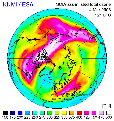
For the days of March of the SO2 plots, the ozone value varies considerably
along a given longitude, as can be seen from the images of the ozone field on
the right for 5 March and 6 March (click to see the
ozone field for
4 March).
[Ozone images taken from the archive of the
TEMIS global total
ozone field.]
|
|
|


