|
Back to
NRT
|
-

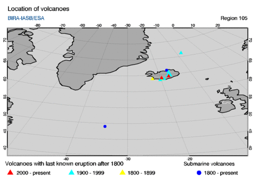
- region type: rectangular region
- region size: 40 by 40 degrees
- region centre: (longitude,latitude) = (-30,60)
-
- Most recent SO2 concentration date for this region:
-
This region encompasses the following volcanoes with last known eruptions
since 1800 AD. The name of a volcano in the table below is a link to
an info-page at the website of the
Global Volcanism Programme (GVP).
The table gives the summit elevation (in meters) and the year of the last
known eruption, omitting any uncertainties in these given at the GVP
website.
        location
      long.    lat.  summit  year   volcano name
   =================================================

     -17.33   64.42   1725   2011   Grímsvötn
     -19.70   63.98   1491   2000   Hekla

     -16.78   65.73    650   1984   Krafla
     -20.28   63.43    279   1973   Vestmannaeyjar   [1]
     -16.72   64.65   1920   1968   Kverkfjöll
     -16.75   65.03   1516   1961   Askja
     -19.05   63.63   1512   2011   Katla   [2]
     -17.53   64.63   2000   2015   Bárdarbunga

     -22.50   63.88    230   1926   Reykjanes
     -19.62   63.63   1666   2010   Eyjafjallajökull

   submarine volcanoes

     -34.50   49.00  -1650   1884   Unnamed
     -17.10   66.30   -100   1868   Tjörnes Fracture Zone   [3]
Notes based on the GVP website:
- This volcanoes is listed as submarine,
but with a summit above sealevel ...
- This volcanoes is listed as subglacial.
- This volcano is listed as submarine, but no summit
elevation is given; the entry here is a dummy value.
|