|
Back to
NRT
|
-

- region type: rectangular region
- region size: 40 by 40 degrees
- region centre: (longitude,latitude) = (90,0)
-
- Most recent SO2 concentration date for this region:
-
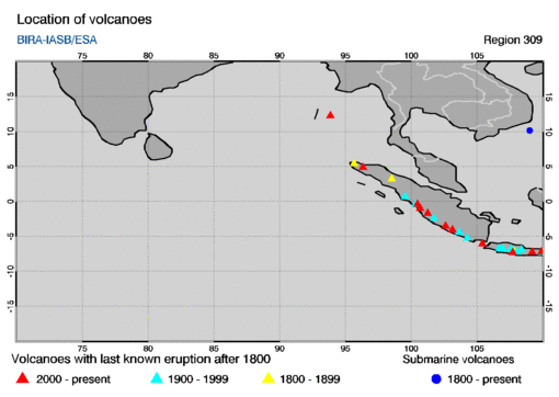
This region encompasses the following volcanoes with last known eruptions
since 1800 AD. The name of a volcano in the table below is a link to
an info-page at the website of the
Global Volcanism Programme (GVP).
The table gives the summit elevation (in meters) and the year of the last
known eruption, omitting any uncertainties in these given at the GVP
website.
        location
      long.    lat.  summit  year   volcano name
   =================================================

     109.92   -7.20   2565   2009   Dieng Volcanic Complex
     109.21   -7.24   3428   2009   Slamet
     105.42   -6.10    813   2020   Krakatau
     103.13   -4.03   3173   2009   Dempo
     101.26   -1.70   3800   2020   Kerinci
      93.86   12.28    354   2020   Barren Island
     100.68   -0.98   2597   2007   Talang
     100.47   -0.38   2891   2018   Marapi
     107.73   -7.32   2665   2002   Papandayan
     102.62   -3.52   1952   2000   Kaba
      96.33    4.91   2801   2000   Peuet Sague
      98.39    3.17   2460   2019   Sinabung

      99.54    0.69   2145   1986   Sorikmarapi
     108.06   -7.25   2168   1984   Galunggung
     107.60   -6.77   2084   1983   Tangkubanparahu
     109.99   -7.30   3136   1971   Sundoro
     106.98   -6.78   2958   1957   Gede
     108.40   -6.89   3078   1951   Cereme
     103.67   -4.43   1899   1940   Besar
     106.70   -6.75   1699   1939   Perbakti-Gagak
     106.73   -6.72   2211   1938   Salak
     104.27   -5.25   1000   1933   Suoh
     100.32   -0.43   2438   1924   Tandikat
     101.73   -2.41   2507   1921   Sumbing

      98.52    3.23   2212   1881   Sibayak
     107.84   -7.14   2249   1847   Guntur
      95.66    5.45   1810   1839   Seulawah Agam

   submarine volcanoes

     109.01   10.16    -20   1923   Ile des Cendres
|