Criteria for exceptional SO2 concentrations
The near-real-time processing issues a notification of exceptional SO2 concentrations by email to users who have subscribed to that service; see this page for an introduction and description of what is provided by the notification service.
The criteria for exceptional SO2 concentrations for the SO2 data have been set up by examining the results of the retrieval and analysis processes. The results of notification events found by the processing are the source for the continuous (qualitative) validation of the notification service.
Since the measurement method and data structure of different satellite instruments is different, the criteria for a notification necessarily have to be different too.
Criteria for SCIAMACHY data
SCIAMACHY measurements alternate between a nadir and a limb viewing mode.
For the SO2 retrieval only the data of the nadir viewing mode can be used,
hence the gaps in the plots of the orbits. With this manner of measuring in
mind, the natural entity of SCIAMACHY data is a nadir state, which consists
of 13 forward and backward scans of 960 km wide (in the normal viewing
modes). In the forward direction a nadir state measures about 500 km.

For the analysis only the ground pixels part of each forward scan are
considered; these are also the pixels plotted in
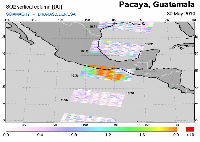
daily data at orbit coordinates,
an example of which is given in this graph of the SO2 vertical column.
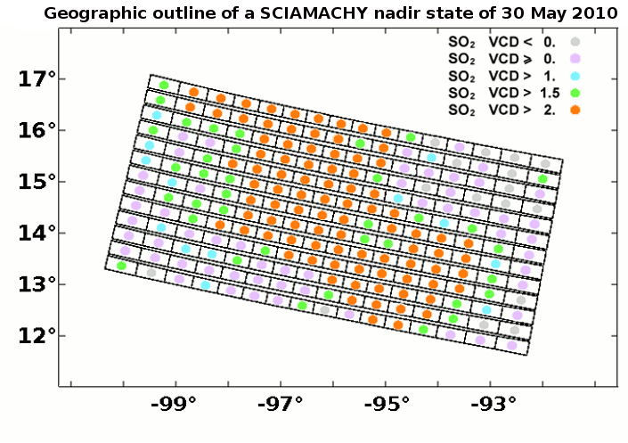
The following graph shows an geographic overview of all the forward ground
pixels of the nadir state just below the centre of the above SO2 vertical
column plot. A coloured circle in each ground pixels indicates the value of
the SO2 vertical column. Note that if the SO2 concentration is very low, then
the DOAS retrieval may results in a negative vertical column, with an error that is of the same magnitude.

|
|
Geographic outline of the SCIAMACHY nadir state just below the centre
in the first graph. The blank rectangles show the outlines of the
forward pixels of the nadir state. Colour circles indicate the level
of the SO2 Vertical Column Density (VCD); grey ground pixels have a negative VCD,
which indicates that there is very little to no SO2.
|
On the basis of this schematic outline the following procedure is followed
to see whether the nadir state should trigger a notification to be issued.
For each ground pixel in the nadir state that has an VCD of more
than 2 DU, the pixels around it are scanned. Each of these eight
pixels that have an VCD greater than 2 DU counts as +1 point.
And each of these pixels that have an VCD less than zero counts as -1 point,
as sharp gradients in the SO2 (i.e. from +3 to less than zero) usually
indicate that the signal may not be real.
The maximum number of points awarded to any given ground pixel in the nadir
state is thus 8. If the number of points is 5 or more, then a notification is
issued for this nadir state.
For ground pixels along the edges of a nadir state things are a little
different as part of the information needed is missing: it lies outside
the state. For that reason, the two points one further along the edge
are also considered in the awarding of points, while one point is
substracted because the pixel is at the edge. This means that ground pixels
along an edge of the state can be awarded at maximum 6 points and can
therefore also trigger a notification. (For ground pixels in the corners there
really is too little information available to let these trigger a notification.)
To see which predefined geographic regions are to mentioned in the notification for
the current state, it is checked within which of these regions lie the
centre coordinates of the individual ground pixels of the nadir state.
For a geographic region to be marked the centre coordinate should lie inside
the region by at least 2 degrees in latitude and longitude.
|