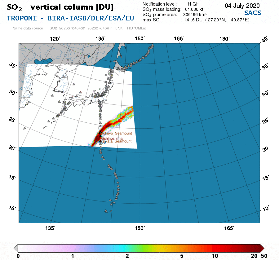
grey layout spacer                                                 NEAR REAL-TIME       NOTIFICATIONS       PRODUCTS      
print page
                                                            TROPOMI        region 211    

Date                         :  2020/07/04
Time                         :  04:09 UTC
SO2 max (previous corrected) :   57.6 DU  (lat:  27.01 N;  lon:  140.49 E;  SO2 height:  8.55 km)
SO2 max                      :  141.6 DU  (lat:  27.29 N;  lon:  140.87 E;  SO2 height:  3.34 km)
SO2 mean                     :    8.5 DU  (lat:  29.96 N;  lon:  142.82 E;  SO2 height:  4.98 km)
SO2 mass loading             :   61.636 kt
SO2 plume area               : 306166 km2
Notification level           :     HIGH
Volcano erupting             :  Nishinoshima   (most likely)
Cloud data                   :  used for VCD
SZA                          :   20.2 deg.
Name data source             : SO2_202007040409_202007040611_LNK_TROPOMI.nc


T
R
O
P
O
M
I
SO2 height
TROPOMI - SO2 height of 2020/07/04

                    Improved SO2                
TROPOMI - improved SO2 vertical column of 2020/07/04  
   
R
E
G
I
O
N
Volcanoes
REGION - Volcanoes close to the alert of 2020/07/04


Links to the near-real-time data pages
with maps from different instruments

NRT > 211 ==  150.0  30.0


Links to the list of volcanoes
in the nearest defined regions

volcanoes > 211 ==  150.0  30.0


Back

 
TEMIS Home Page  PROMOTE Home Page  O3M SAF Home Page Last update on 12 Oct 2020