

|
|

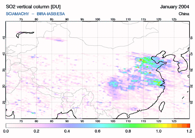
One of the serious negative consequences of the People's Republic of China's rapid industrial development has been increased pollution and degradation of natural resources. Much solid waste is not properly disposed of. Water pollution is a source of health problems across the country and air pollution causes up to 750,000 premature deaths each year. China's polluted environment is largely a result of the country's rapid development and consequently a large increase in primary energy consumption, which is primarily provided by coal power plants. China has pursued a development model which prioritizes exports-led growth (similar to many other East Asian countries).Sulphur dioxide (SO2) is one of the main constituents of air pollution over China, along with nitrogen dioxide (NO2), carbon dioxide (CO2), etc. SO2 related to anthropogenic activities will usually remain close to the ground, or more precisely: in the boundary layer (the lowest few kilometre). This means that this SO2 can be measured from satellite only in cloud-free situations, and for that reason the daily maps of SO2 over China show large variations.
It is therefore worthwhile to consider monthly averages. But rather than looking at the SO2 distribution assuming the peak is at an altitude of 14 km or 6 km (respectively with the option AMF High and AMF Middle as is done for the plots shown in the archive), it is better to assume that the SO2 is in the lowest 2 km above ground level (option AMF Low), which means that the SO2 is found only in the planetary boundary layer - a fair assumption for SO2 from anthropogenic activities. In addition, the colour scale is adapted to better show the SO2 distribution. See the next two plots which show montly SO2 vertical column for July 2010 with AMF Middle and AMF Low options (with respectively assumed peaks at 6 km and 2 km). This page shows SO2 averages over different periods in time based on SCIAMACHY data from the data archive, gridded on a 0.25 by 0.25 degree grid. A discussion, with some validation and trend analysis, of the data can be found in the following paper:
SCIAMACHY dataYearly averages (AMF Low)
Long-term averages ("climatologies")
Monthly averages
the large images for the available months and - if available - the yearly average.
You can contact us if you want to see the last images of China (SCIAMACHY and GOME-2). |


