Eruption of the Kasatochi volcano
on the Aleutian Islands
August 2008
|

Kasatochi volcano from the southeast on 23 Aug. 2008.
[Image: Chris Waythomas; source:
AVO/USGS
website]
|
On 8 August 2008 an alert was issued shows a large SO2 concentration patch
with a very high SO2 peak value. The cloud is no doubt related to the
eruption of the Kasatochi volcano on the Aleutian Islands (52.17N, 175.51W;
summit 314 m), a volcano that has not been active for more than 200 years.
According to messages on the Alaska Volcanic Observatory:
A US Fish and Wildlife field crew reported feeling earthquakes on Kasatochi
around August 2, 2008. On August 7, the level of earthquake
activity increased and was also accompanied by volcanic tremor. The field
crew has been evacuated off Kasatochi. By 22:30 UTC, satellite data showed
an ash plume to an altitude of at least 35,000 ft.
Satellite imagery of e.g. AVHRR showed a big ash cloud moving away from the
volcano in a wonderful spiral (see
this image taken on
8 Aug.). The eruption has lead to cancellation of 44 flight from
Alaska Airlines on 10-11 August.
The eruption blew large amounts of SO2 into the atmosphere, up into the
lower stratosphere, which was subsequently transported across the Northern
Hemisphere, as the details given below show. In addition to SO2 other gases
were released during the eruption, including a large amount of BrO --
which was the first time volcanic BrO was seen from satellite.
SO2 detection from 7 August onwards
|
About 2 hours after the eruption OMI passes over the volcano and detected a
small cloud of SO2 with a peak value of 238 DU!! (this value is
probably not correct, as such high SO2 concentrations saturate the retrieval
process) -- see the image on the right.
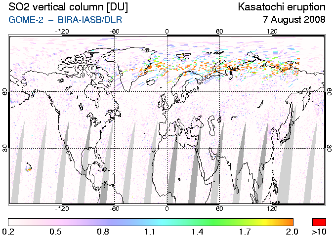
On this map, the SO2 is almost overhead of the volcano. GOME-2 measured over
that area on 7 Aug. at about 21:45 UTC. and SCIAMACHY shortly after that,
i.e. just before the eruption, and they saw nothing.
The next day, 8 August, SCIAMACHY measured very large concentrations, with a
peak of 136 DU, close to the volcano and on account of this SACS issued
an alert. By then the SO2 cloud has grown quite a bit, as the following
images show.
|
|

SO2 from Kasatochi as seen by OMI at 00:15 UTC on 8 August 2008;
since the orbit during which this measurement was made started on 7 Aug.,
the map is dated 7 Aug.
|
 |
 |
 |
|
SO2 cloud from Kasatochi as seen by (from left to right)
by GOME-2, SCIAMACHY and OMI in the evening of 8 August 2008.
(Click on the images to enlarge.)
|
During the days following the eruption, it appeared that a really massive
amount of SO2 was released and a very large SO2 cloud moves to the East,
drifted a bit to the South and then started going North-east with a beautiful
curl. On 10 Aug. the cloud reached the Canadian coast. On 11 Aug. the cloud
stretched out in a curl across Canada, all the way to the far north, with
another curl reaching into the USA.
Image showing sulphur dioxide measured by OMI and volcanic ash measured by
AVHRR on 10 August 2008, around 23:00 UTC. Note that the SO2 cloud
covers a much larger area than the ash cloud; minor amounts of ash may be
associated with the gas cloud, though. The red triangle to the left marks
the location of the volcano.
Image courtesy of AVO/USGS
Source: Alaska
Volcano Observatory
|
|
 |
Movie of SO2 transport across the Northern Hemisphere
Kasatochi released SO 2 in three or four phases over a period of
several hours, and depending on the altitude reached by the SO 2
and the winds at the time, the SO 2 follows different tracks across
the Northern Hemisphere in the days after the eruption. This can be
seen nicely when combining the SO 2 maps of GOME-2 and OMI into one
animation.
|
Animation of the SO2 cloud from Kasatochi as seen by
by GOME-2 and OMI from 7 to 23 August 2008.
GOME-2 measures a few hours before OMI, and therefore the movie shows a
small jump going from a GOME-2 to an OMI image, followed by a larger
jump going from the OMI image to the GOME-2 image of the next day.
(Grey means no data.)
Click here for:
|
|
 |
Web links
|


